Friday, June 21, 2013

Missing Images of Saint John Streets


Missing Images of Saint John, N.B.  -  I  have enough photographs of the old UNION STATION to fill a book.   Shots taken from every possible angle, but one.  I have not seen a single photograph of the station, Mill Street or the Viaduct, taken from a window of the Lord Chamberlain Hotel, and that defies logic.  Think of all the ceremonies that took place at the station, including Royal Visits.  You don't have to think like Lee Harvey Oswald to realize what a great perch the hotel was.


Missing Images  No. 2 -  a year or two ago I joined in discussion of this Isaac Erb photograph of the old Shamrock Grounds (Fairview Plaza in our time).  This image is pre-WW1.  It was the practice of Saint John photographers to seek elevation for unique shots -  church spires, grain elevators, hotel roofs, etc.  In the North End,  the spire of St. Lukes Church on Main Street, offered the best unobstructed view from height.  I am amazed that no professional photographs taken from the spire have yet turned up.  All of our elevated shots of the area were taken from Fort Howe hill.


Missing Images  No. 3  -  I have frequently discussed missing images with my old pal, Harold Wright, who has one of the larger private collections of Saint John photos.  I'm sure we both have images of streetcars on each of the track lines which once threaded through the city, and we agree that one line still goes undocumented with photos. There are no images extent of street cars on the the tracks which ran from Hawker's Corner up Paradise Row and then right onto Wall Street.  Passengers had to change cars at the bridge, crossing the old humped bridge on foot.


Missing Images No. 4  - and finally, one more Valley landmark that simply disappeared without a trace. There was once a very popular performing stand erected at the base of Garden Street, on the triangular lot.  In the late 19th Century press it was mentioned more often than any other band stand and it must have been photographed many times, yet we never see it.  Our loss.

Thursday, May 30, 2013

Saint John - The City of Tomorrow (1946)


In 1946  the City of Saint John published a set of proposals which were intended to radically reshape the structure and use of the inner core, and require all future developers to abide by a management plan which would govern thinking and investment for decades into the future.  The plan would of course necessitate the demolition of much of the decrepit housing stock, "slums, the existence of which had become a great source of embarrassment and official anxiety. One of the great national rallying cries during WW2 was the promise of postwar "rebuilding".  In Saint John the emphasis would be on eradicating traffic bottlenecks  and the developing of modern residential nodes, which was being proto-typed with the  Rockwood Court housing project, and Fundy Heights.

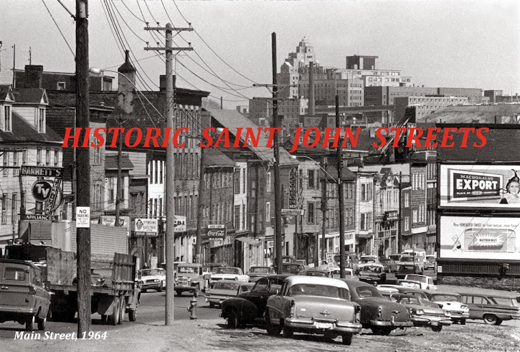
Almost all of the large scale proposals were never built, with the exception of the massive concrete viaduct on Mill Street,  which would straddle the Valley and link the North End to the "Uptown".   What Saint John planners did witness in the Atomic Era was a very large uptick in private automobile ownership.  The old walking city became the driving city,  and suddenly gas stations were everywhere - North, South, East, West and yes, several in the Valley. 

It's fascinating to look over the surviving illustrations of what City Fathers hoped would become their "City of Tomorrow", a term not used in their report but very much in vogue in post-war North America.


In this interesting Birds Eye View of the "Central City," we see that the artist incorporated a mid-century concept of what a Harbour Bridge might look like.  Note that Fort Howe was intended for development.  What I find most significant is that planners had not yet given up on the Valley, and expected that it would to contribute to the city, as it had done for a century.


Saint John mayors and aldermen were in the habit of junketing to Boston and New York,  so I must assume that at least a few of them took in the "Futurama"exhibit at New York's World Fair.


A good view of Market Slip and Market Square.  Planners saw the old slip as an artifact,  not the commercial hub it had been since since the Loyalist Era.  Some creative had to be done with it.

More than anything else, Saint John planners wanted to get rid of the dangerous level crossing on Mill Street, in front of the train station.

The proposal for the great concrete Viaduct was the most important proposal which went forward. The removing of Hawker's Corner and connecting of Main Street to Mill Street above the rail tracks,  was a great accomplishment, although within a decade the "new" viaduct was already considered outmoded.
Please refer to my article "Terraforming the Old Saint John - Portland Valley"


I like this image of the Union Station section of the Valley, for several reasons.  I find it highly amusing that the concept artist was directed to scrape clean all of the tenements existing on Main Street, Paradise Row and Rockland Road  in 1946, but tiny  Mission Church on Paradise Row is permitted to live on.  That is a fair indication that in post war Saint John you could easily imagine dispossessing slum dwellers of their homes but you dare not mess with the established Church.

This is a map of proposed "neighborhood units".   In the parlance of modern Canadian planning, they would be termed "Town Centres".

I also like this design for the proposed re-housing area East of Waterloo Street.  Some of this was accomplished with the later Urban Renewal sweeps of the 1960s.  The General Hospital has since been demolished but the Catholic cathedral and a few of the buildings which made up the old Catholic precinct, are still standing.

This image of what they proposed for the old Shamrock Park, a combined football and baseball facility, is noteworthy. There is an interesting story behind this, which I will tell sometime in THE LOST VALLEY BLOG.  For now it enough to remind you of what actually happened. Developers put in the Fairview Shopping Plaza, and Shamrock Park was rebuilt in Indiantown.


This illustration is from an American magazine of 1946, and seems very relevant here.  What really happened in Saint John after the war was that the citizen's took the development of the city in directions of their own choosing.  It wasn't pretty but it was passionate. I can write without fear of contradiction that what most young entrepreneurs in the Loyalist City wanted above all was to own their own neighborhood filling station.


I hope you enjoyed this photo essay.
Ronald  J. Jack
ronjackbc@yahoo.ca

Wednesday, May 29, 2013

Saint John - The Market Square - St. Lukes Church sight-line (1870 - 1970)

Please note - An article which further explains these historic images can be read at the parent website -  THE LOST VALLEY -  Blogging the History Of Saint John.   You can jump to this specific article with one CLICK.


St. Lukes Church - built in the Town of Portland, N.B., 
which later amalgamated with the City of Saint John.


An elevated shot made in 1870 allows us to look over the roof line
of North Market Wharf (Market Slip) and pinpoint the spire of 
St. Lukes Church  on Main Street in the town of Portland, N.B.

The Great Saint John Fire of June 1877 destroyed so much
that for a year or two it was possible to see St. Lukes Church
in the far distance -  while standing in Market Square.


Another elevated shot, circa 1970, sets us up for
the next pair of photos -  a rare view of the 
> Market Square  - St. Lukes Church sight-line<
which opened  up briefly as a result of the
Urban Renewal Demolition Program of the 1970s.


Market Square just after Urban Renewal cleared
Dock Street and punched a hole big enough to
restore the view of St. Lukes over in the North End.


A view from Market Square which we will not
see again for many years - assuming of course,
that historic St. Lukes Church continues to survive.

Tuesday, May 28, 2013

Flat Iron Buildings in Saint John, N.B.


Readers of my long running Saint John history Blog will realize that I have compiled a great deal of photographic material, most of which I cannot work into feature length Blog articles.  There was an obvious need for a Photo-Blog to share images of our lost buildings and streetscapes.  

HISTORIC  SAINT JOHN  STREETS will be purely visual.

SAINT JOHN  HISTORY  MUSEUM  will be archival .  A gateway for researchers.

THE LOST VALLEY - Blogging the History of Saint John, N.B.  will continue to be where I tell interesting stories of the past, and advocate for the preservation for what is left of the old Saint John we cherish.

Each brief photo-essay in this Blog will deal with a specific aspect of Historic Saint John Streets.  It could be a named street,  a landmark building,  a public or private facility, or in fact anything which interests me, from bridges to back alleys.  I begin today  with:


FLAT IRON  BUILDINGS  IN  SAINT JOHN 


303  Union Street  (Demolished)

36  St.  David  Street  (Demolished)

517 - 523  Main Street  (Demolished)

Corner of Union and Waterloo Streets  c. 1925.  This 
was the store of dispensing druggist E. Clinton Brown.


One for the reader to puzzle over. Clue?
 Frank F. Williams adopted some very modern
concepts of grocery. Where was his store?


Flat Iron buildings can still be found in other New Brunswick towns and cities.

Here is one on Water Street in Miramichi, New Brunswick  (view)
and another on Main Street in Moncton  (view).